
Natural Phenomenon
“From the vast cavern in to which you are passing comes the sound of a thousands storms. You hear the mad winds raging around the walls of their imprisonment, and mingling their fearful roars with the reverberating thunders of the cataract!“
- Pecks’ Tourist Companion to Niagara Falls, 1845
Niagara Falls
Niagara Falls is a natural phenomenon that is overwhelming in its magnitude and deeply embedded in popular consciousness. Over Niagara Falls courses the outflow of four of the Great Lakes and 20% of the world’s fresh water. The distinctive characteristics of the Niagara Falls region can only be understood through appreciation of this unparalleled resource and the geological processes that surround it.
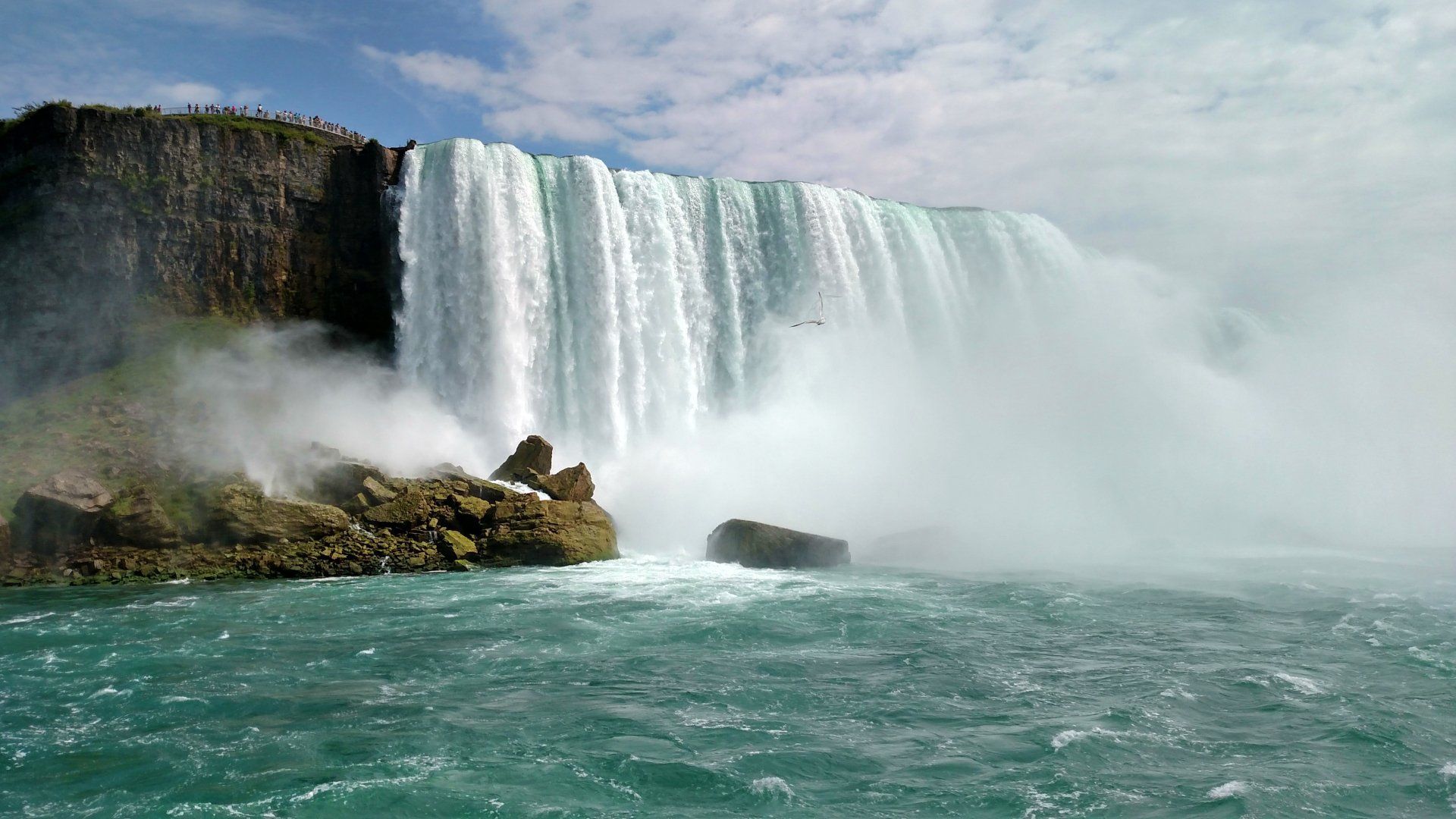
With a vertical drop spanning more than 165 feet, Niagara Falls has the highest flow rate of any waterfall in world. The natural phenomenon known as Niagara Falls is the collective term for three waterfalls, located on the Niagara River. Lying between United States and Canada, the American Falls, Horseshoe Falls and the Bridal Veil Falls together form Niagara Falls.
Niagara Falls creates the southern end of the Niagara Gorge, creating the most magnificent transitional point in the Great Lakes System, connecting the waters of Lake Erie to Lake Ontario through the Niagara River corridor. Within a second, during peak flow season, 750,000 gallons of water descend over Niagara Falls.
Near the end of the last ice age, around 12,500 years ago, the Niagara River began to flow over a large cliff known as the Niagara Escarpment. The cliff is located at the northern end of the Niagara Gorge. It is here that Niagara Falls first formed. Over thousands of years the falls carved through the underlying rock, and as the falls receded due to erosion, it formed the 6.8 mile gorge that we see today.
The Niagara Gorge
The Niagara Gorge offers visitors a chance to explore a truly unique area rich in wildlife and geologic history. Stretching about 6.8 miles, the southern end of the Niagara Gorge is Niagara Falls while the northern end is the Niagara Escarpment, a large cliff-like landform where Niagara Falls first formed 12,500 years ago. The sedimentary rocks of the Niagara Gorge are studied by geologists from all over the world. Layers of rock forming the walls of the gorge are dated to be 440 million years old. Each unique layer has a different role in the Niagara Region’s vast geological story. Throughout the gorge, the mighty Niagara River tosses and turns from rapids to whirlpools, giving it the title as one of the most powerful river currents in the world. Geology is only one part of the marvel that makes up the Niagara Gorge. Visitors can also get a close look at a unique environment full of beautiful birds, plants, and breathtaking scenery at several places along the Niagara Gorge Trail.
The Niagara River
Niagara River The origin of the Niagara River is at the north-east end of Lake Erie. From there, it flows north to its mouth at Lake Ontario. About 35 miles in length, the Niagara River features several islands, rapids, whirlpools and Niagara Falls in its course. Historically, the Niagara River served as the gateway to the west with Native Americans and early European explorers portaging around Niagara Falls to travel to the interior of the North America. It was a core part of the extensive trade route that brought fur pelts from America’s interior to Europe via the Great Lakes and the St. Lawrence River. In the early 19th century, the Niagara River and its tributaries formed the last part of the Erie Canal increasing commerce and making Niagara Falls accessible for millions of visitors. For those escaping slavery in the southern United States before and during the Civil War, the Niagara River was one of the final destinations on the Underground Railroad before freedom seekers entered Canada. By the mid to late 19th century, advances in engineering led to multiple bridges spanning the Niagara River. In the late 1880’s, advances in science changed humankind when the Niagara River became the first waterway in North America to be harnessed for large-scale generation of hydroelectricity. Throughout the National Heritage Area, visitors can take in both the raw beauty and history of the Niagara River.
The Escarpment
Formed 450 million years ago from layers of sand, silt and clay, the Niagara Escarpment is an extensive landform visible as a line of steep slopes and long bluffs extending from New York State through Ontario, Michigan, Wisconsin and Illinois. The Niagara Gorge is the channel cut through the escarpment by the Niagara River over time, and Niagara Falls is the present location of that erosive action. The Niagara Falls and Gorge may be the Escarpment’s best known landscape features. The microclimates and environmental conditions created by the Niagara Escarpment, Niagara River and Gorge support a unique range of plant and animal ecosystems. As visitors travel from Niagara Falls to Lewiston or Youngstown, they will travel down the Escarpment. At its peak, there is a tremendous vista featuring the Niagara River, Lake Ontario, and even Toronto, Canada on clear days.
Great Lakes
The Great Lakes are the largest freshwater lakes in the world containing 20% of the world’s fresh water. Spanning across northeastern North America, they consist of Lake Superior, Lake Michigan, Lake Huron, Lake Erie and Lake Ontario. The Niagara River connects Lake Erie to Lake Ontario. At the northern end of the National Heritage Area is western end of Lake Ontario.